Europe
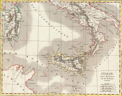
Italie, Partie Méridionale
Italy. Original map on steel by T. Duvotenay. Paris, 1835. Very good condition. Folds. Hand-coloured. 23x18cm.
Sold
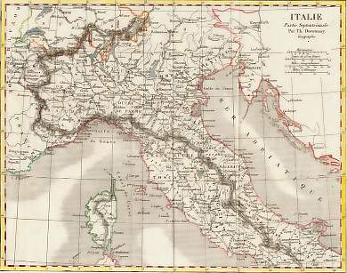
Italie, Partie Septentrionale
Italy. Original map on steel by T. Duvotenay. Paris, 1835. Very good condition. Folds. Hand-coloured. 23x18cm.
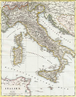
Italien
Italy. Original map on steel engraved by J. L. von Baehr after G. Heck. 1856. Light foxing in the margins. Hand-coloured. 26x20,5cm. Matted.
Sold
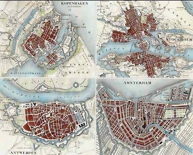
Kopenhagen, Stockholm, Antwerpen, Amsterdam
North Europa. Original city map on steel, engraved by R. Schmidt and Mädel after G. Heck. 1856. Good condition. Hand-coloured. 25x20cm. Matted.
Sold
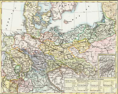
Königreich Preussen
Germany. Original map on steel, engraved by J. von Baehr after P. Weber. 1856. Good condition. Hand-coloured. 26x20,5cm. Matted.
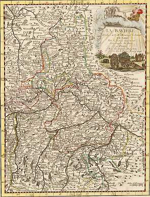
La Bavière, Dédiée à S. A. Monsieur Le Comte De Saxe...
Germany. Original map by Georges Louis Le Rouge. Copper engraving. 1743. Very good condition. Decorative cartouche, central fold. Hand-coloured. 26x20cm. Matted.
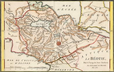
La Béotie, Pour Le Voyage Du Jeune Anacharsis, Mai 1787
Greece. Original copper map, engraved by G. de la Haye after J. D. Barbié du Bocage. 1791. Light foxing. Fold. Hand-coloured. 25,5x16cm. Matted.
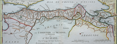
La Corinthie, La Sicyonie, La Phliasie et L´Achaie, Pour Le Voyage Du Jeune Anacharsis, Juin 1786
Greece. Original copper map, engraved by G. de la Haye after J. D. Barbié du Bocage. 1791. Light foxing. Fold. Hand-coloured. 30,5x12cm. Matted.
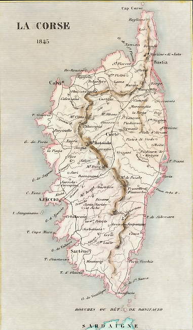
La Corse
Corsica. Original map on steel. 1845. Very good condition. Hand-coloured. 17,5x10cm. Matted.
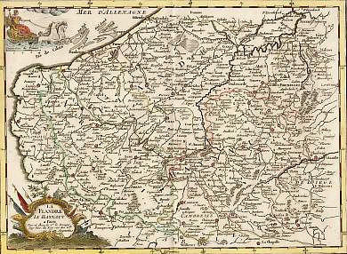
La Flandre, Le Haynaut
Flanders and Hainaut. Original map by Georges Louis Le Rouge. Copper engraving. 1756. Very good condition. Decorative cartouche, central fold. Hand-coloured. 27,5x20cm. Matted.
Sold
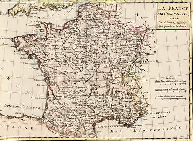
La France
France. La France par Généralités, dressée par Mr. Bonne, Ingénieur-Hydrographe de la Marine. Original fold map by Rigobert Bonne. Geneva, 1780. Very good condition. Copper engraving. Hand-coloured. 32x21cm. Matted.
Sold
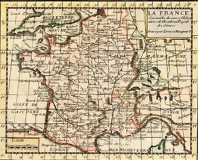
La France
France. La France suivant les dernières observations de l´Académie Royale des Sciences. Original copper fold map, engraved by D. Macquart after Claude Buffier. 1736. Very good condition. Hand-coloured. 17,5x14cm. Matted.
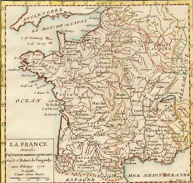
La France Divisée Par Gouvernements Géneraux
France. Original small map by Robert De Vaugondy. Copper engraving. Paris, 1750. Small repaired hole. narrow margins. Outline hand-coloured. 15x15cm. Matted.
Sold
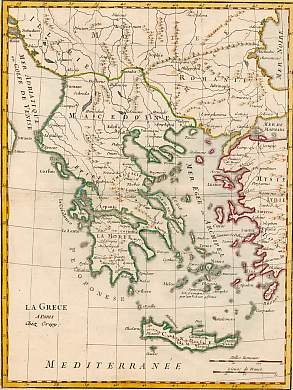
La Grèce
Greece. Original map. "A Paris, chez Crepy". Copper engraving. 1767. Very good condition, central fold. Hand-coloured. 27,5x20,5cm. Matted.
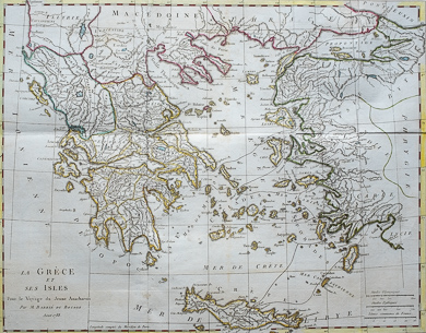
La Grèce et Ses Isles, Pour Le Voyage Du Jeune Anacharsis, Août 1788
Greece. Original copper map, engraved by G. de la Haye after J. D. Barbié du Bocage. 1791. Good condition. Fold. Hand-coloured. 44x35cm. Matted.
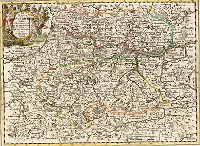
La Haute Autriche, Dédiée à Monseigneur Le Maréchal De Broigle...
Austria. Original map by Georges Louis Le Rouge. Copper engraving. 1743. Very good condition. Decorative cartouche, central fold. Hand-coloured. 26x20cm. Matted.
Sold
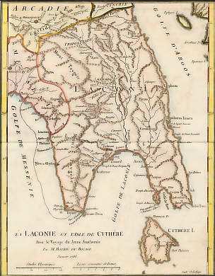
La Laconie Er L´Isle De Cythère, Pour Le Voyage Du Jeune Anacharsis, Janvier 1786
Greece. Original copper map, engraved by G. de la Haye after J. D. Barbié du Bocage. 1791. Light foxing. Fold. Hand-coloured. 26,5x21cm. Matted.
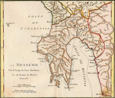
La Messénie, Pour Le Voyage Du Jeune Anacharsis, Janvier 1786
Greece. Original copper map, engraved by G. de la Haye after J. D. Barbié du Bocage. 1791. Light foxing. Fold. Hand-coloured. 22,5x19cm. Matted.
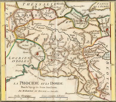
La Phocide et La Doride Pour Le Voyage Du Jeune Anacharsis, Juin 1787
Greece. Original copper map, engraved by G. de la Haye after J. D. Barbié du Bocage. 1791. Very good condition. Fold. Hand-coloured. 19,5x16cm. Matted.
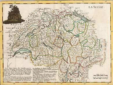
La Suisse
Switzerland. Original map. 1767. Copper engraving. Very good condition, central fold. Hand-coloured. 27x20cm. Matted.
Sold
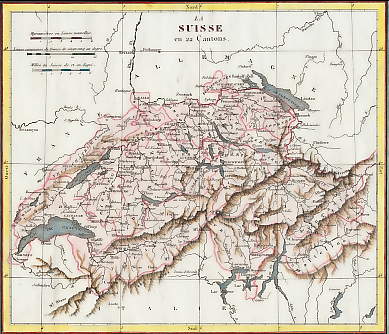
La Suisse En 22 Cantons
Switzerland. Original copper map, engraved by Rousset. 1833. Very good condition. Hand-coloured. 21x18cm. Matted.
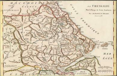
La Thessalie, Pour Le Voyage Du Jeune Anacharsis, Janvier 1788
Greece. Original copper map, engraved by G. de la Haye after J. D. Barbié du Bocage. 1791. Light foxing. Fold. Hand-coloured. 29,5x19,5cm. Matted.
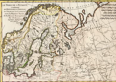
Le Nord De L´Europe
North Europa. Le Nord de l´Europe, contenant le Danemark, la Norwege, la Suede et la Laponie, avec la Majeure Parie de la Russie Européenne, par Mr. Bonne, Ingénieur-Hydrographe de la Marine. Original fold map by Rigobert Bonne. Geneva, 1780. Very good condition. Copper engraving. Hand-coloured. 32x21cm. Matted.
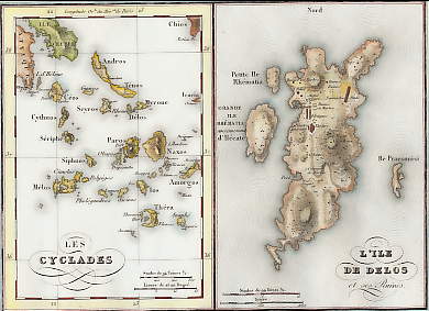
Les Cyclades, L´Ile De Delos
Greece. Original copper map drawn and engraved by A. Tardieu. 1826. Very good condition. Hand-coloured. 20,5x15cm.
Sold
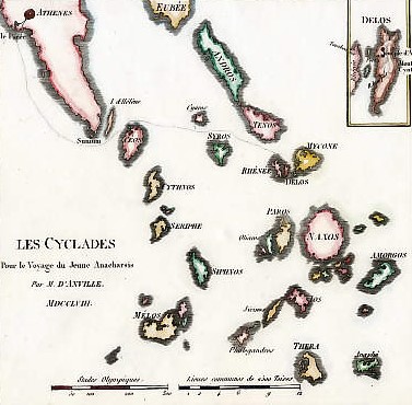
Les Cyclades, Pour Le Voyage Du Jeune Anacharsis, 1788
Greece. Original copper map by J. D. Barbié du Bocage. 1819. Light foxing. Hand-coloured. 18x17,5cm. Matted.
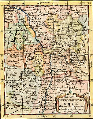
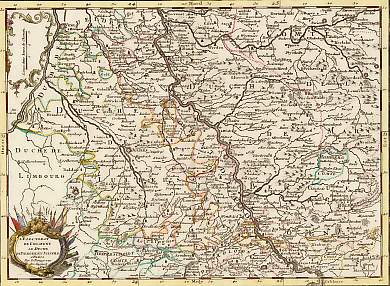
Les Deux Cercles Du Haut et Du Bas Rhin, Suivant Les Degrez De L´Académie Des Sciences De Paris, 1714
Germany, France... Original copper fold map by Claude Buffier. 1736. Good condition. Hand-coloured. 17,5x14cm. Matted.
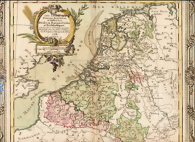
Les Pays-Bas Francois, Autrichiens et Hollandois Divisés En Provinces Civiles et Ecclésiastiques
Netherlands. Original copper fold map by L. Brion de la Tour and L. C. Desnos. 1766. Very good condition. Decorative border. Hand-coloured. 31x29cm.
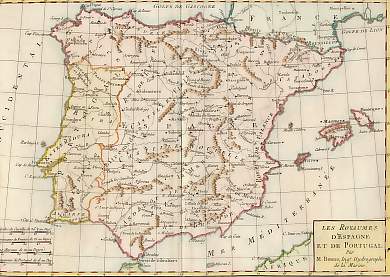
Les Royaumes D´Espagne et De Portugal
Spain and Portugal. Les Royaumes D´Espagne et De Portugal, par M. Bonne, Ingénieur-hydrographe de la Marine. Original fold map by Rigobert Bonne. Geneva, 1780. Two repaired holes. Copper engraving. Hand-coloured. 32x21cm. Matted.
Sold
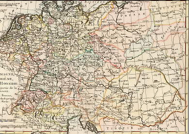
L´Allemagne, La Bohême et La Hongrie
Germany, Ungary and Poland. L´Allemagne, La Bohême et La Hongrie: avec une partie de la Pologne, par Mr. Bonne, Ingénieur-Hydrographe de la Marine. Original fold map by Rigobert Bonne. Geneva, 1780. Very good condition. Copper engraving. Hand-coloured. 32x21cm. Matted.
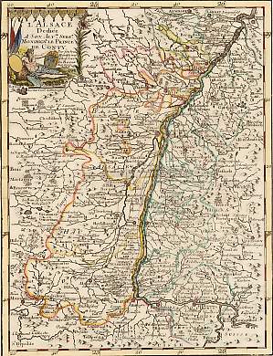
L´Alsace, Dédiée à S. A. S. Monseigneur Le Price De Conty
France. Original map by Georges Louis Le Rouge. Copper engraving. 1743. Very good condition. Decorative cartouche, central fold. Hand-coloured. 27x20cm. Matted.
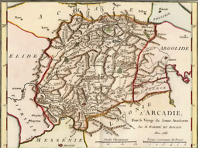
L´Arcadie, Pour Le Voyage Du Jeune Anacharsis, Mai 1786
Greece. Original copper map, engraved by G. de la Haye after J. D. Barbié du Bocage. 1791. Very good condition. Fold. Hand-coloured. 21x16cm. Matted.
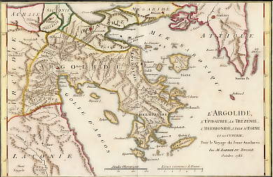
L´Argolide, L´Épidaurie, La Trézénie, L´Hermionide, L´Isle D´Egine et La Cynurie, Pour Le Voyage Du Jeune Anacharsis, Octobre 1785
Greece. Original copper map, engraved by G. de la Haye after J. D. Barbié du Bocage. 1791. Light foxing. Fold. Hand-coloured. 28x18cm. Matted.
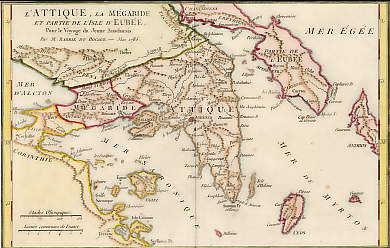
L´Attique, La Mégaride et Partie De L´Isle D´Eubée, Pour Le Voyage Du Jeune Anacharsis, Mai 1785
Greece. Original copper map, engraved by G. de la Haye after J. D. Barbié du Bocage. 1791. Light foxing. Fold. Hand-coloured. 28x18cm. Matted.
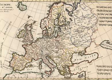
L´Europe
Europe. Original fold map by Rigobert Bonne. Geneva, 1780. Very good condition. Copper engraving. Hand-coloured. 32x21cm.
Sold
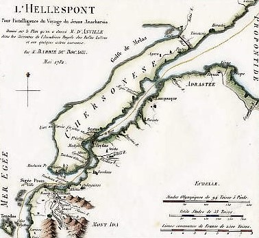
L´Helles-Pont, Pour L´Intelligence Du Voyage Du Jeune Anacharsis, Mai 1782
Turkey. Original copper map, engraved by P. de la Haye after J. D. Barbié du Bocage. 1819. Light foxing. Hand-coloured. 19x17,5cm. Matted.
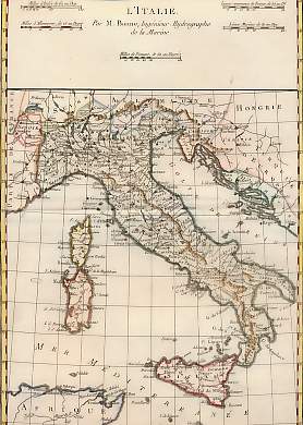
L´Italie
Italy. Original fold map by Rigobert Bonne. Geneva, 1780. Very good condition. Copper engraving. Hand-coloured. 32x21cm.
Sold
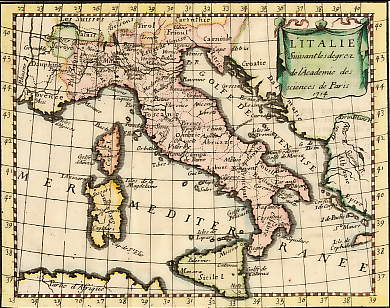
L´Italie Suivant Les Degrez De L´Académie Des Sciences De Paris, 1714
Italy. Original copper fold map by Claude Buffier. 1736. Very good condition. Hand-coloured. 17,5x14cm. Matted.
L´Électorat De Cologne, Le Duché De Bergue et Juliers
Germany. Original map by Georges Louis Le Rouge. Copper engraving. Paris, 1743. Very good condition. Decorative cartouche, central fold. Hand-coloured. 27x20cm. Matted.
Sold
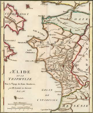
L´Élide et La Triphylie, Pour Le Voyage Du Jeune Anacharsis, Août 1786
Greece. Original copper map, engraved by G. de la Haye after J. D. Barbié du Bocage. 1791. Light foxing. Fold. Hand-coloured. 20,5x17cm. Matted.
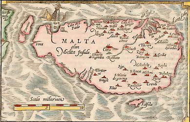
Malta Olim Melita Insula
Malta. Original wood map by François de Belleforest. 1575. In-text. Very good condition. 16x10cm. Matted.
All prices include VAT.
Upon ordering there may be additional costs for shipping.
 +49 40 4204212

